Shocking Videos Show Storm Surge Tearing Through Areas of Florida as Hurricane Ian Makes Landfall
Hurricane Ian officially made landfall near Cayo Costa, Florida at 3:05 P.M. on Wednesday as a near category five hurricane with maximum sustained winds at 150 mph.
The National Hurricane Center continues to warn of “life-threatening storm surge, catastrophic winds and flooding in the Florida Peninsula” as millions are under evacuation orders.
Clips of the storm surge inundating coastal areas like Fort Myers, very near to where the hurricane made landfall, show the extent of the devastation.
The Weather Channel’s Mike Bettes posted a stunning clip from a street camera showing an intersection in Fort Myers completely underwater as winds raged.
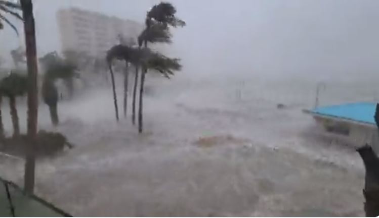
“*RARE* first person view of storm surge. This camera is 6 feet off the ground on Estero Blvd in Fort Myers Beach, FL. Not sure how much longer it keeps working,” Bettes noted of the clip.
Here is what this view typically looks like pic.twitter.com/HZjzPBr8h2
— Mike Bettes (@mikebettes) September 28, 2022
Whoa! #Ian https://t.co/hjQb2q4FkF
— Mike Bettes (@mikebettes) September 28, 2022
Other meteorologists shared clips from elevated balconies at coastal hotels showing the Gulf of Mexico below them. “That was the pool area of this hotel. It is now part of the Gulf of Mexico,” said CBS’s Manuel Bojorquez.
Reporting live in Fort Myers, Florida, @BojorquezCBS shows the dangerous storm surge from Hurricane Ian.
“That was the pool area of this hotel. It is now part of the Gulf of Mexico.” pic.twitter.com/QTW7Oxc2VR
— CBS News (@CBSNews) September 28, 2022
In the eye wall of #Hurricane #Ian in Fort Myers. We’re live on @weatherchannel along with @StephanieAbrams and @JimCantore #HurricanIan pic.twitter.com/gSBdmAUjWX
— Mike Seidel (@mikeseidel) September 28, 2022
Storm surge at Ft Myers Beach. 📷 Matt Settles. #Ian pic.twitter.com/SWAE6yfEFe
— Paul Dellegatto⚡️FOX (@PaulFox13) September 28, 2022
Charlotte County Emergency Management director Patrick Fuller warned as the hurricane made landfall that the storm surge would only continue to rise. “The storm surge, we are still at the very beginning of that. We will see that continue throughout the afternoon into the evening. It’s going to begin to fill up canals, overtop land, and potentially into homes. We are going to see life-threatening storm surge,” he said.
Overlaying building footprints reveals that this won’t just be an inundation of the tidal zone. Thousands of buildings will be underwater in Cape Coral alone. pic.twitter.com/jV9aJUtydk
— Evan Fisher (@EFisherWX) September 28, 2022
Evan Fisher created a graphic showing what the predicted storm surge would like in the Fort Myers area.
Below are more clips showing conditions ahead of Ian’s landfall, including a shark coming ashore and reporters dodging debris as they brave the elements:
⚠️ Horrific scene in Matlacha/Pine Island, Florida where storm surge and strong Cat 4 winds from #HurricaneIan has battered the small island community. pic.twitter.com/cdmKQLjYd5
— Alejandro Galiano ❁ (@havanahistory) September 28, 2022
Reporting live in Fort Myers, Florida, @BojorquezCBS shows the dangerous storm surge from Hurricane Ian.
“That was the pool area of this hotel. It is now part of the Gulf of Mexico.” pic.twitter.com/QTW7Oxc2VR
— CBS News (@CBSNews) September 28, 2022
Holy crap! Hit by flying tree branch pic.twitter.com/lubWULMT6B
— Daniel Chaitin (@danielchaitin7) September 28, 2022
Here is a time-lapse of the #StormSurge coming in on Sanibel Island, #Florida caught on a live traffic cam. This was only 30mins condensed down, it deteriorated quickly. 😬 #HurricaneIan #Hurricane #Ian pic.twitter.com/JKuNROvMm4
— BirdingPeepWx (@BirdingPeepWx) September 28, 2022
#BREAKING: Video circulating shows houses FLOATING off their foundations in Fort Myers Beach. Hurricane #Ian. pic.twitter.com/OID6YATFd3
— Moshe Schwartz (@YWNReporter) September 28, 2022
For more on Hurricane Ian in the media, click here.
New: The Mediaite One-Sheet "Newsletter of Newsletters"
Your daily summary and analysis of what the many, many media newsletters are saying and reporting. Subscribe now!


Comments
↓ Scroll down for comments ↓