Weather Channel Illustrates Warnings About Hurricane Laura Storm Surge With Alarming Simulation
As of Wednesday night, the National Hurricane Center is warning that Hurricane Laura is “extremely dangerous” and that it will bring with it “unsurvivable storm surge with large and destructive waves” from Texas to Louisiana.
The National Hurricane Center has forecasted "unsurvivable storm surge" from Hurricane #Laura in parts of Louisiana and Texas. Do NOT underestimate this storm.
This is what that kind of water height looks like: pic.twitter.com/ik7EtpFTzn
— The Weather Channel (@weatherchannel) August 26, 2020
Here are the Key Messages for extremely dangerous Hurricane #Laura for Thu pm. An unsurvivable storm surge with large and destructive waves is coming soon for Sea Rim State Park TX to Intracoastal City, LA, including Calcasieu and Sabine Lakes & could penetrate 40 miles inland. pic.twitter.com/k6Ds0jAjni
— National Hurricane Center (@NHC_Atlantic) August 27, 2020
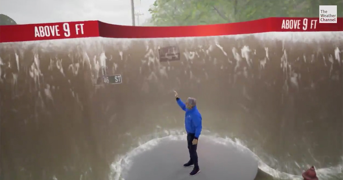
The Weather Channel has once again put together an alarming simulation to help inform viewers through disturbing visuals how serious the storm is going to be.
Storm surge flooding at just three feet means it’s “too late to evacuate” and cars will be floating.
But there are places that could be facing over nine feet of water and possibly up to twelve.
“This is why you need to pay attention to the latests forecasts for Laura, and evacuate now as ordered to do so. It just may save your life,” Greg Postel told viewers.
New: The Mediaite One-Sheet "Newsletter of Newsletters"
Your daily summary and analysis of what the many, many media newsletters are saying and reporting. Subscribe now!


Comments
↓ Scroll down for comments ↓