You Can See The Pentagon and Kremlin in High Def On Google Earth. Why Not Gaza, West Bank, Parts of Israel?
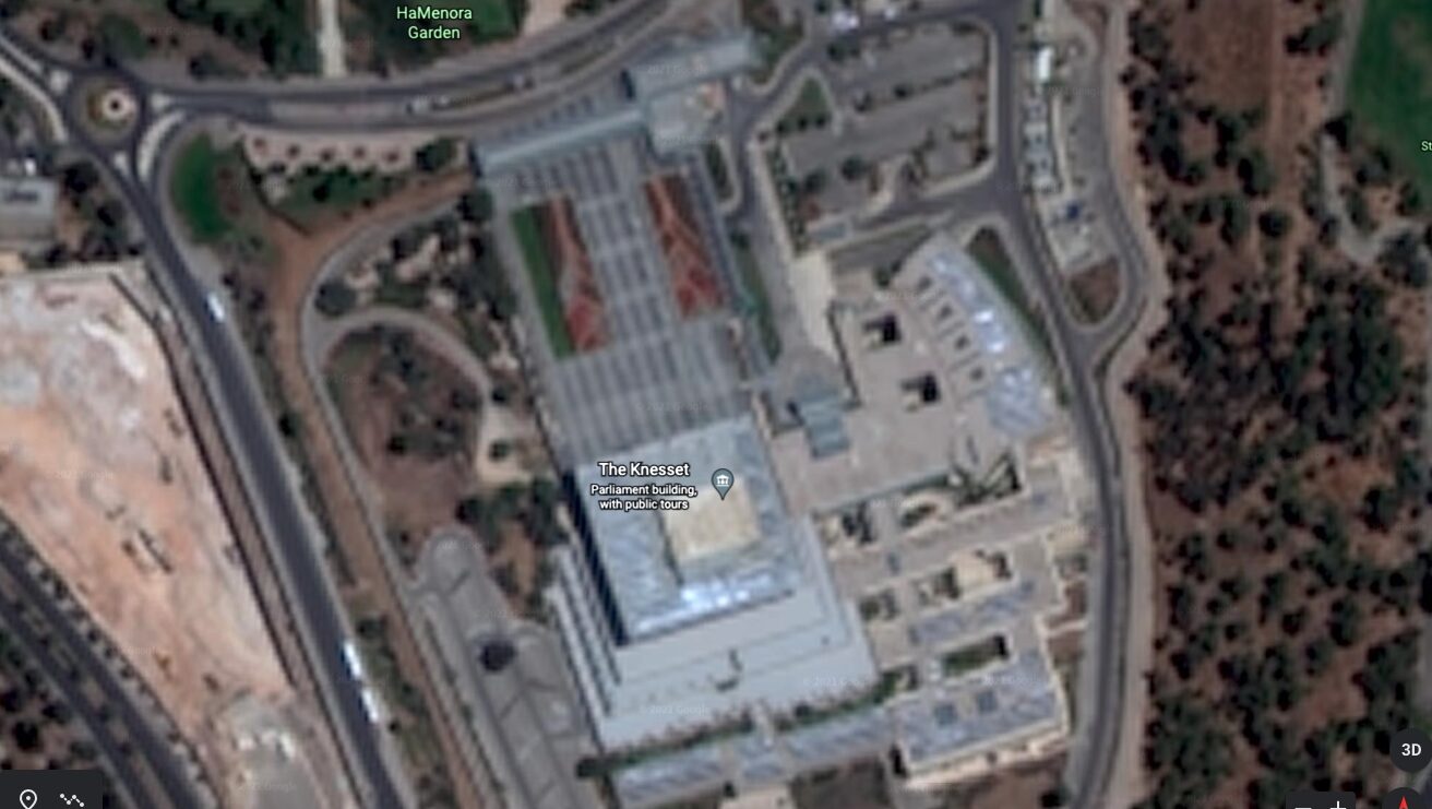
Satellite image of the Knesset in Jerusalem via Google Earth
A search on Google Maps will yield high-resolution images of some of the world’s most secretive, highly-guarded places, including the Pentagon, the headquarters of Russia’s GRU military intelligence agency, Westminster in London, and even Pyongyang in North Korea. But someone looking for similarly-detailed images from over Israel, Gaza, and the West Bank will find only blurry, low-resolution images – and that’s not by accident.
According to Israeli newspaper Haaretz, which published an in-depth explainer Thursday, a decades-old amendment to an American defense law has kept high-resolution images of the region from public view.
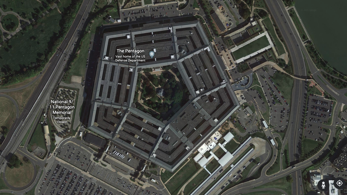
Satellite image of the Pentagon in Washington via Google Earth
The restriction can be traced back to 1997, when the Kyl-Bingaman Amendment (KBA) to the U.S. National Defense Authorization Act was enacted. It prevented U.S. companies, including Apple and Google, from providing and distributing high-resolution satellite photos of Israel.
“The amendment had been put in place after years of tension between Israel and the U.S. regarding restrictions and regulations of satellite images and technology,” Haaretz said in its report. That tension included then-President Bill Clinton’s decision to declassify more than 800,000 Cold War-era satellite images. Many media reports followed the release of the pictures, including one in an Israeli daily paper that published a decades-old aerial shot of an Israeli nuclear reactor taken by a U.S. spy satellite.
According to Haaretz, citing a peer-reviewed study in the journal Space Policy, “a day after the Israeli report, Republican Sen. Jon Kyl ‘presented it as a reaction to Clinton’s declassification of the spy satellite photographs.’” Kyl said that Clinton’s order “could unintentionally have a deleterious impact on the national security of the State of Israel.” The KBA, co-sponsored by Democratic Sen. Jeff Bingaman, was passed, and interpreted to cover the West Bank and Gaza Strip as well as Israel.
It’s not as if high-res images of the region weren’t available at all, Haaretz explained. The amendment just limited what U.S. companies could do. European firms, not bound by American legislation, were able to provide high-resolution images to those willing to pay for it.
But now, following a June 2020 decision by the U.S. to ease restrictions and allow U.S. companies to sell high-resolution images, such images may soon become more readily available. (At least one Israeli official flagged the move as a possible security risk: “I don’t think [the U.S.] asked us” in advance before loosening the restriction, an Israeli Defense Ministry official told Haaretz at the time – an interesting statement considering the close relationship between Israel and the administration of former President Donald Trump.)
Indeed, as Haaretz reports, some high-res images taken by U.S.-based companies have already started to make their way into the public eye. The Associated Press has published high-res images of an Israeli nuclear center, which were purchased from San Francisco-based Planet Labs, a private “Earth imaging company,” Haaretz reported. Planet Labs has also reportedly taken photographs of “another secretive site in central Israel that, according to foreign sources, is home to an air force base,” Haaretz said.
Haaretz said that one potential impact of the loosening of the KBA restrictions is that “Israel is now at greater risk of losing its information advantage in the field.”
“From a defense perspective, this can, at least in theory, supply better and more accurate information to those looking to harm Israel,” Dr. Shira Efron, an expert in Israeli national security told Haaretz, adding that Israel is concerned that Hamas and Hezbollah could use the images to plan more accurate strikes on civilian and military targets.
While Efron said it’s unclear whether the high-res photos would make a difference, as “most of the enemies in our proximity are not targeting Israel at the level of a specific person … nonetheless, from a defense perspective, for Israel – the blurrier, the better.”
On the other hand, as Haaretz pointed out, high-res satellite images could “help bridge the gap” in understanding the impact of Israel’s recent deadly and destructive military strikes on Gaza, where access is either limited or impassible.
To laypeople and non-governmental organizations interested in keeping an eye on the area – like those who have tracked human rights abuses and violence in China, Syria, Yemen, and Ukraine – the information that high-res satellite images could provide is just not readily available from free commercial sources, such as Google, Haaretz said. According to one Israeli expert quoted by Haaretz, the reason for that is “technical and bureaucratic,” although one Google spokesperson told Haaretz that the company “consider[s] opportunities to refresh our satellite imagery as higher-resolution imagery becomes available and have no plans to share at this time.”
Although the high-res images may start to emerge as a slow trickle, it’s not unreasonable to expect that it will eventually turn into a steady stream. As the interactive images accompanying the Haaretz story show, the difference between high-res and lower-res images is dramatic and undeniable. High-resolution satellite pictures from the region may eventually become the norm (as they already are in the rest of the world), even if Israel has spent decades hiding part of its defense strategy behind blurry satellite images and a legislative amendment specifically aimed at limiting the power of a president to release Cold War-era images.


Comments
↓ Scroll down for comments ↓